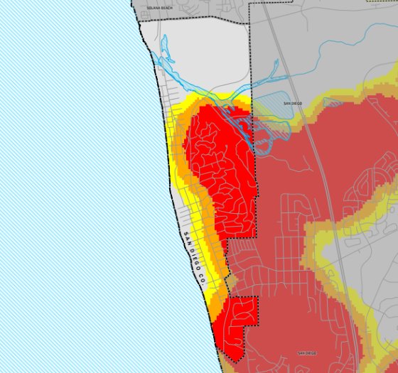
State releases Fire Hazard Security Zone maps
Cal Fire’s updated “Fire Hazard Severity Zone” maps for California identify classifications for fire risk in the City of Del Mar.
Released March 24 by the Office of the State Fire Marshal, the maps display hazard levels—moderate, high and very high—based on the likelihood of a fire reaching an area and the fire’s potential intensity.
The maps account for conditions such as vegetation type, density, terrain, weather, winds and fire history. For cities or “local responsibility areas,” the maps are designed to ensure that fire-preventative codes apply in appropriate areas.
State law requires local agencies to adopt the maps by ordinance within 120 days of their release.
In Del Mar, presentations and hearings by fire officials are expected to begin in April following a detailed evaluation of what the identified changes—which expand and increase Del Mar’s fire risk levels—will mean for the community.
While the public is encouraged to review the maps and submit comments using the form provided in the link below, under State law the City is not allowed to modify the maps to decrease the fire risk area identified by the Office of the State Fire Marshal. Only recommendations from local agencies to increase their levels of responsibility within Fire Hazard Severity Zones will be permitted.
Open webpage
Comment on Fire Hazard Zone Severity Map